|

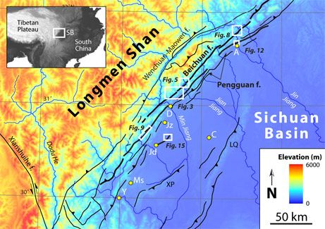
文章提到的卫星拍摄的断层图像
5月12日四川省北川县发生的致命地震之前的约10个月,一项科学报告就已经警告中国地区将面临一次大型地震。
科学家们通过仔细研究卫星图像,且对四川省的地壳断层的十年来的深度和活动研究之后,发出了以上警告。
在2007年7月中期的《地壳》杂志中,中国,欧洲和美国的科学家们写道:“断层的长度已经足以引发一次强烈的撼动地面的地震,它的潜力将成为爆发区域性地震的来源。
科学家的结论是,地壳撞击的能量在北川聚积,并将以地震的形式释放出来。
现在看来这个预言精确的甚至让人不寒而栗,当研究人员将活动的断层在北川的彩色地图上标示了出来时,那里正好这场地震的震中。(见附图)
来自田纳西的孟菲斯大学的地震研究和信息中心的Micheal Ellis,同时也是这项研究的联合作者之一,表示“据我所知,这是对这些活跃断层的唯一调查。”
发生于5月12日的7.9级地震几乎将四川省的部分地区夷为平地。中国官方今天估测死亡人数将到达5万人,几乎5百万人将无家可归。
锁进了杂志
可以确信中国官方对2007年7月的报告完全没有察觉,否则事情绝不会沦为现在的局面。
“我们已经明确的标示出了这些活跃断层的潜力,”Ellis说到。“但这个信息事实上被锁进了一份学术期刊。”Ellis希望能用防震建筑替换如今已经塌陷的建筑,这样起码可以避免未来的悲剧。
“(地震前)我曾经去过这些小型村镇”,Ellis说,“大多数房屋都没有使用加固材料,而且那些地区几乎没有制砖厂。”
他补充说,“制造防震建筑成本相对较高,但四川省的绝大多数人民却十分贫困。”
地震背后的科学
北川的地震活动并不罕见。
“我们的证据显示从12000至13000年前开始,北川就始终伴随着使地表断裂的地震。”Ellis和同事在去年夏天的报告中写到。
在接受国家地理新闻的采访时,Ellis说到,“根本上说,(2008年)地震的原因是印度和亚洲地壳板块持续且不可阻挡的碰撞,其速率约为一年20-22毫米。”
此次碰撞起始于5千万年前,当时印度下方板块撞向了欧洲板块。
Ellis补充说“喜马拉雅和青藏高原便是从这个碰撞中产生的。”
随着印度板块持续缓慢的撞向亚洲,猛烈的时候就产生了地震,整个青藏高原都被向北推动。
“这次地震是西藏的山区向东边成都平原移动”,一位没有参与2007年7月报告的地质学家,科罗拉多大学的Roger Bilham说到。
问题不局限于四川
报告的联合作者Ellis说,随着西藏高原北移,“西藏的中部地区正在塌陷,就像奶酪刚从烤箱中拿出来放到冷空气中一样。”
Ellis指出,西藏的南部边缘在断层一侧,其面对的地震威胁和四川一样大。
Ellis补充说:“喜马拉雅地区相关的财产和生命损失的风险非常之大,因为有大量的人口居住在哪里或者马上迁移过去。”
“这风险几乎和四川一样高,因为人口和,类似于印度尼泊尔的,相对劣质的建筑标准。”
而且,随着印度板块持续撞向西藏,“它正在制造新的断层”,同时也意味着新的危险。
本文来自于美国的国家地理杂志National Geographic
原文地址:
http://news.nationalgeographic.com/news/2008/05/080516-earthquake-predicted.html
Study Warned of China Quake Risk Nearly a Year Ago
Kevin Holden Platt in Beijing
for National Geographic News
May 16, 2008
Just ten months before a deadly earthquake struck Sichuan Province's Beichuan county on May 12, a scientific study warned that the Chinese region was ripe for a major quake.
After examining satellite images and conducting on-the-ground inspections of deep, active faults in Sichuan Province for more than a decade, scientists issued a warning.
China earthquake predicted (map)
"The faults are sufficiently long to sustain a strong ground-shaking earthquake, making them potentially serious sources of regional seismic hazard," the Chinese, European, and U.S. geoscientists wrote in the mid-July 2007 edition of the journal Tectonics.
They concluded that clashing tectonic forces were growing in Beichuan, ready to burst in an explosion of seismic energy.
With precision and what now seems like eerie foresight, the researchers charted the active faults on multicolored maps of Beichuan, which turned out to be the epicenter of the recent earthquake.
"As far as I know, this is the only investigation of these active faults," said study co-author Michael Ellis of the Center for Earthquake Research and Information at the University of Memphis in Tennessee.
(Related: "China Quake Delivered Seismic One-Two Punch" [May 15, 2008].)
The magnitude 7.9 quake that struck on May 12 almost entirely leveled parts of Sichuan Province. Chinese officials today estimated that the death toll would reach 50,000 and that nearly five million people are homeless.
(See photos of the earthquake's destruction.)
"Locked in a Journal"
There is little reason to believe Chinese officials were aware of the July 2007 report, or that it would have made much difference if they had been.
"We had certainly identified the potential of these active faults," Ellis said. "But that information was effectively locked in an academic journal."
Ellis hopes that replacing the collapsed buildings with earthquake-proof structures could prevent future tragedies.
"I've been to these little towns [before the quake]," Ellis said. "Most of the houses are built of unreinforced masonry, and you can see little brick factories all around this area.
China earthquake predicted (map)
"It is more expensive to build earthquake-proof structures," he added. And the vast majority of people in Sichuan Province are anything but rich.
The Science Behind the Quake
Earthquake activity is nothing new in Beichuan.
"We have shown evidence for surface-rupturing earthquakes along the Beichuan fault since 12,000-13,000 years ago," Ellis and colleagues reported last summer.
Speaking with National Geographic News, Ellis said, "Ultimately, the [2008] earthquake is related to the continuing and inexorable collision of India with Asia, which is occurring at a rate of about 20 to 22 milimeters [just under an inch] per year."
This collision started more than 50 million years ago, when the tectonic plate beneath India crashed into the Eurasian plate. (Watch how the plates slammed into each other.)
"The Himalayas and all of Tibet was created by this collision," Ellis added.
As the Indian plate continues its slow-motion crash into Asia—sometimes in jerks marked by earthquakes—it is pushing the entire Tibetan Plateau northward.
"This earthquake was the Tibetan mountains moving east over the plains of Chengdu [the capital of Sichuan Province]," said Roger Bilham, a geoscientist at the University of Colorado who was not involved in the July 2007 study.
Not Just Sichuan's Problem
Study co-author Ellis said that, as the Tibetan Plateau moves northward, "the interior parts of Tibet are collapsing, rather like a soufflé taken out of the oven into cold air."
Faults along the southern, Himalayan edge of Tibet present hazards as great as those underlying the Sichuan temblor, Ellis said.
"Risk associated with the loss of collateral and lives is very high along the Himalaya, because so many people live there or immediately downstream," Ellis added.
"The risk is similarly high in Sichuan [to the east], because of the population and, like India and Nepal, the relatively poor building standards," he said.
And as India continues to pound into Tibet, "it is still creating new fault lines"—and new dangers.
|